
What are some of the coolest places in the world… according to a geologist’s point of view? Geology is the study of earth – how it forms, what it is made of, etc. Thus, I decided to make a list of stunning places that are neat representations of common and rare geological processes. As it is the year 2020, I have highlighted 20 sites. Yes, this list is biased a bit with sites I’ve visited, know about, and are somewhat accessible… However, I have only visited a handful of them (which I denote with a * in the title). How many have you seen? Any nominations for a site I missed or you disagree with? Leave a comment below or connect with me on Twitter: @stephsykora or Instagram: @stephaniesykora 🙂
#1. Cueva de los Cristales “cave of giant crystals” (Chihuahua, Mexico)

These giant crystals are by far the coolest on the list I think… because they look unreal. But they definitely are real. This cave is known as la Cueva de los Cristales. It contains some of the largest crystals ever discovered, up to 12 metres (m) long and 4 m wide. They are a form of gypsum [CaSO4H2O] called selenite. This crystal cave is located 120 m deep, with temperatures that can get up to 60°C and 100% humidity. These hot and humid conditions, and the previous flooded nature of the cave (with waters rich in calcium and sulphate), allowed such massive crystals to form. The cave was accidentally discovered by silver and lead miners in Mexico in 1910.
Visiting la Cueva de los Cristales?
Unfortunately it is very hard to get there, and therefore not the most accessible geological place to visit. But you can go with a guide and training apparently. If I ever make it there I will keep you posted more on this! In the meantime, we can admire the photos online.
#2. Uluru* (Northern Territory, Australia)

This is the most famous rock in Australia, and probably also the world. Uluṟu (previously known as Ayers Rock) is a ~ 550 million year old isolated rock (inselberg) of arkosic sandstone. It has actually been tilted on its side by 90° since its formation way-back-when. Uluṟu is really a huge rock that continues for possibly 5 to 6 km below the surface, sort of like an iceberg for comparison. You can see the sub-vertical layers and ribs that have been accentuated by years and years of erosion in the Aussie outback. The actual colour of Uluṟu is grey sandstone. However, it has turned to orange-red on the outer surface due to oxidization of the iron (i.e., rusting) in the sandstone overtime.
Visiting Uluru?
You can visit Uluṟu and walk right up to and around it, but not climb on top of it due to it being a sacred site to Aboriginals. It wasn’t technically illegal before 2019, but was considered disrespectful. As Uluṟu is located in the centre of the Aussie outback, getting there requires a long drive from most major cities. Or you can fly to Alice Spring or direct to Yulara (right next to Uluṟu) in the NT.
#3. Giant’s Causeway* (Northern Ireland, U.K.)

Over 40,000 basalt hexagonal columns make up the Giant’s Causeway on the northeast coast of Northern Ireland. Their unique shapes make this one of the most interesting geological sites in Europe. The columns formed via hot, mafic volcanic rock (either lava at the surface or shallow magma just below the surface) cooling and contracting into hexagonal columns. Their formation isn’t that unique though. Similar columns can be seen in many other places around the world (such as the amazing exposures in Tasmania, Australia). However, the combination of the Irish coastline, interesting folklore (the giant Finn McCool & his Scottish bride) and beautiful exposures makes this a special site.
Visiting the Giant’s Causeway?
It is very easy to visit the Giant’s Causeway as it is located on the coast along paved roads (like the Causeway Rd in Northern Ireland). Many roads will lead right to the location. Then it is just a short walk to the exposures along the coast. You can even take a bus via the visitors centre to them.
#4. Grand Canyon (Arizona, U.S.A)

Holding true to its name, the Grand Canyon really is one of the most grand and impressive canyons (and geological sites) in the world. It is ~ 450 km long and up to 1.5 km deep in areas. One of the reasons it is so impressive is that it literally is a slice into hundreds of millions of years of time captured in the rock record. The rocks at the bottom of the canyon formed first and are Proterozoic age… over 1 billion years old. Whereas, the rocks above it towards the top formed later and are Mesozoic age… only a few hundred million years old. You can see this sedimentary rock history (stratigraphic column) beautifully exposed on the walls. Its carved canyon shape is due to the retreat and erosion from the Colorado river over time.
Visiting the Grand Canyon?
As it has been an established national park since President Roosevelt, the Grand Canyon can be driven to and explored easily. It is full of many informative posts and trails. You can raft through the canyon below, or hike on trails that go along the top or down to the bottom.
#5. Kilauea volcano* (Hawaiʻi, U.S.A)

Hawaiʻi is not just a tropical paradise, but a superb geological destination. Hawaiʻi consists of multiple small islands that formed over a “hot spot” of magmatic activity in the middle of the Pacific Ocean. As the Pacific tectonic plate moved (and continues to move) over the hotspot, new volcanoes and islands are formed. The most southern and active island is the Big Island, home to Mauna Loa and Kīlauea volcanoes. Kīlauea is the most active volcano today. Regular eruption still build the island via pāhoehoe and ʻaʻā lava flows. Because of this, it is one of the most stunning places to see young features of a volcano… that are either actively forming or have recently formed. Of course it also poses a threat, like most volcanoes do, to the buildings and people below. But due to the slow-moving characteristics of lava from these shield-type volcanoes, the eruptions are more effusive and flow slowly, rather than being catastrophic with sudden fast pyroclastic flows.
Visiting Kilauea volcano?
Hawaiʻi has popular flights to Oʻahu and Maui islands, however, from there many small regular flights that go to Kailua-Kona or Hilo on the Big Island. From there you can rent a car and drive to the Hawaiʻi Volcanoes National Park on paved highway 11 towards the Kīlauea Visitor Centre. Or there are many tours that operate day trips out of the main towns. I would advise to check the government website prior for any closures in case the volcano is in a phase of increased activity (www.nps.gov/havo/planyourvisit).
#6. Mid-Atlantic Rift* (Iceland)

There are many, many impressive sites and geological landscapes in Iceland, but this makes the list due to its overall significance. The Mid-Atlantic Rift is an active spreading rift separating two of the largest continental plates in the world: the North American Plate and the Eurasian Plate. As the tectonic plates move apart, magma rises up resulting in basaltic volcanism. Most of the spreading is under the Atlantic Ocean, but the Þingvellir National Park in Iceland is the only above-water expression of the Mid-Atlantic Ridge. It is literally pulling apart Iceland to this day! If you go you can also claim to stand on North America and Europe at the same time 😉
Visiting the Mid-Atlantic Rift?
Þingvellir is on the popular “Golden Circle Circuit”, so there are well-maintained roads and many tours companies go there. Other parts of Iceland, however, might require a 4-wheel drive and the right time of year for open roads. Check ahead on road closure before you go, particularly if there is increased volcanic activity (www.road.is/travel-info/road-conditions-and-weather/).
#7. Yellowstone National Park (Wyoming, U.S.A)

This famous national park in the USA is full of active geothermal hot springs, geysers, mud pools, fossilized plants and animals… and a super volcano. The park’s spectacular geothermal features are fueled by a shallow magma source under the surface (upwelling magma from way deep-down in the earth). One of the largest volcanic eruptions known on earth occurred at Yellowstone ~ 2.1 million years ago (mya), and again at 1.3 mya. Yellowstone volcano is monitored regularly for seismic activity, volcanic gas concentrations, ground deformation, etc. So even though an apocalyptic eruption is unlikely in the next hundreds to thousands of years, it is still possible, especially in the next tens of thousands to millions of years.
Visiting Yellowstone National Park?
The park’s constant monitoring of the site, and small recent eruptions (i.e., acting as pressure releases), make Yellowstone safe enough for visitors. It is a well-established and maintained national park with lots of hikes and tourist information sites. Just make sure to stay on the trails and paths, and do not take any rocks with you as a “souvenir”. You can check out www.nps.gov/yell for more information on the park.
#8. Shilin Stone Forest 石林 (Yunnan, China)

This is an extensive “forest” of limestone rocks, one of the best examples of a humid tropical karst landscape. Overtime slightly acidic waters (like rain water) have slowly eaten away (eroded) the reactive and soluble calcium carbonate limestone. This erosion is what created the formations that look like pillars or trees, thus giving it the name “Stone Forest”. It is huge (~ 550,000 km2), and like many of the geological sites on this list, it also has a folk legend to it (the legend of Ashima). The limestones are about Permian Age (~ 270 million years old), and once formed underwater in a shallow sea. Parts of the forest are UNESCO World Heritage Sites and has been known about since the Ming Dynasty.
Visiting the Shilin Stone Forest?
The stone forest is an established tourist site. There is a visitor center with information and the main entrance. You can get there via bus, hired car or there is a train stain relatively nearby.
#9. Galapagos Islands* (Ecuador)

The Galapagos Islands are most famous for their unique creatures and the inspiration for Charles Darwin’s Origin of Species and theory of evolution papers. Did you know that Darwin was actually a geologist? Though obvious his interests were in biology and ecology as well. The islands are similar to this too, in the sense that along with being biologically unique, there are also very unique geologically. The islands are made of young volcanic rocks. They formed because they are sitting on top of a mantle plume (similar to Hawai’i). This is a hot, buoyant column of magma that rises from deep within the earth. As it rises, pressure decreases near the surface, causing melting that forms magma chambers. Then more magma rises through the solid upper crust to emerge as volcanic islands.
Visiting the Galapagos Islands?
The islands are welcoming to tourists and tour group operators. It does require a flight, usually via the Ecuador cities of Quito or Guayaquil. Another option is via small cruises boats or sail boats. Many places are restricted without a licensed guide so taking a tour group is recommended here.
#10. Yosemite Valley* (California, U.S.A.)

A famous spot not only for its imposing granite cliffs, but as a mecca for climbing. From El Capitan to Half Dome, the mountain names here have some of the most famous names and reputations for rock climbing in the world. This glacial-carved valley is the heart of an ancient, exposed magma chamber. These types of igneous rocks form deep (15 to 30 km) below the surface during times of high magmatic activity. With time, they cool, crystalize and are exposed at the surface via uplift. Once at the surface they are eroded and shaped by glaciation. A similar-looking place to Yosemite is the Chief in Squamish, BC, Canada. It is my home town where I grew up so maybe a bit of a bias, but I think it looks like a mini Yosemite…
Visiting Yosemite?
The main highways like 120 and 140 in California go right through the national park, so it is easy to get to. If you plan on camping you will need to book in advance as it gets very popular, especially in the summer. There are easy hikes and short climbs to do. And of course if you are a rock climber there are many fun routes to send!
#11. Meteor Crater (Arizona, U.S.A.)

A truly extra-terrestrial site, Meteor Crater in Arizona is the best preserved meteor impact site in the world. This is largely due to its young age and the dry climate of Arizona. It is an incredible example of a space rock impact site; a good reminded that these giant meteorites do hit earth ever now and then. The site is almost 1.2 km wide and 170 m deep. It was made by a meteor that hit the earth ~ 49,000 year ago. The actual meteor was thought to have been ~ 50 m wide and traveling at ~ 13 km/s. This would have been enough to have a tremendous impact with a explosion equivalent to over 10 million tons of TNT. Meteorite fragments from this impact are known as the “Canyon Diablo” meteorites. They are dominantly composed of iron and nickel with minor cobalt, gallium, germanium, iridium and platinum. Other cool impact sites can be see all over the world, such as the Wolf Creek and Henbury Meteorite crater in Australia.
Visiting Meteor Crater?
Getting there is pretty easy, and there is a museum on site with lots of information about the impact history. It even has some fragment samples of the nickel-iron meteorite. There are view points and some limited hiking allowed in the area. Though, also like the Eye of the Sahara on this list, it is best to see this one from the air.
#12. Eye of the Sahara (Mauritania)

Also known as the Richat Structure, the eye-catching circular structure is best seen from space. It is 45 km across and located in Mauritania in the Sahara Desert in Africa. It is made of dominantly sedimentary (with minor igneous) rocks. Geological it is a formation known as a dome (domed anticline). Time has eroded the original topography, exposing the stratigraphic rock layers. “Anticline” mean that the rocks in the centre are the oldest (~ 1 billion years old) and the outer rings are younger (~ 480 million year old). Thus you can travel through time in the geological layers from the centre outwards.
Visiting the Eye of the Sahara?
In regards to getting there… is it pretty hard. It is located deep in the Sahara desert, and thus you would need a good vehicle, be well prepared and preferably have a local guide. Also, due to its immense size the real appreciation and beauty of this feature is best seen from above!
#13. Kawah Ijen “blue volcano” (East Java, Indonesia)

This active stratovolcano in East Java, Indonesia, is special by the fact that the lava burns blue. It is the only known volcano in the world that does this! It also contains the largest hyperacidic lake in the world (pH ~ 0). Kawah Ijen is part of the 20 km wide circular Ijen Caldera Complex that formed 50,000 year ago, but has been resurgently active since the early 1800s. The unique infamous blue “lava” can only be seen at night… and actually, it isn’t the lava itself that glows, but just a reaction with the atmosphere. It is blue because all the sulfuric gases emitted by the volcano. When the hot molten lava flows and heats up its surroundings with increase temperatures (> 360°C), the sulfur and oxygen in the atmosphere combine and ignite in a faint blue glow. Even in these extreme volcanic conditions, locals miners continue to work inside the volcano to collect sulfur.
Visiting the “blue volcano”?
There are a few ways to actually visit the “blue volcano”. In regards to getting there, you need to have a local guide or tour. Banyuwangi is the main city that they depart from. They leave at night, as that is only when you can see the blue flames.
#14. Burgess Shale* (British Columbia, Canada)

The Burgess Shale (also known as Walcott Quarry), in B.C.’s Yoho National Park is a world famous fossil site. Here there are many hard and soft shell marine critters, preserved beautifully in sedimentary (shale) rocks. About 500 million years ago was an evolutionary “big-bang” called the Cambrian Explosion. Until that time globally there was pretty much only simple, unicellular life and some complex animals but without mineralized skeletal remains. Thus the Cambrian Explosion marks an important experimental evolution event in Earths history with the appearance of hard-shell creatures. During this time the Burgess Shale was underwater when a submarine cliff catastrophically failed and buried the creatures instantly, leading to their preservation we see today. Trilobites “the cockroaches of the Cambrian” are the most abundant fossils here. However, there are many neat examples of other creatures, like the Pikaia (one of the earliest known chordates – i.e., mammals) and the Hallucigenia (spikey creatures that, for the longest time, no one knew which way was right-side up).
Visiting the Burgess Shale?
To get to the site you need to go on a paid guided hike up to the quarry that starts at the Yoho Trading Post near Field, BC. The guides will give you access to the quarry, as it is protected and prohibited to enter without them. Be prepared as it is a challenging full-day hike for 22 km, and with ~ 800 m elevation gain.
#15. Postojna Caves* (Slovenia)

While there are many remarkable cave systems in the world which deserve a spot on the list, I am highlighting this one due to a few reasons. One of which is I am part Slovenian and have been there 😉 But also because of the immense underground cave network that is visitor friendly. The caves have over 24 km of wandering passages underground and contain various cool cave features like stalactites and stalagmites. The caves formed via an underground river (Pivka) ~ 2 million years ago that slowly eroded away at the surrounding reactive limestone bedrock. Cave formations likes stalactites form very slowly (between 0.1 to 0.3 mm/year) by water percolating down from the ceiling and depositing calcite that was dissolved in the water. In the caves also lives a special creature, the Proteus or “human fish”. It is an amphibian with no eyes, no skin colour pigment, and can survive several years without food.
Visiting Postojna Caves?
The caves can be approached via the A1 motorway in Slovenia. You can hire a car, take a bus (to the cave entrance), or get a train that gets you to Postojna (30 min walk away to the cave). That or take a local tour from one of the main cities like Ljubljana or Maribor. There is a tourism center where you need to pay a fee to enter the caves, but it includes a train ride deep into the caverns as well as a guided tour. Nearby is also a cool 16th century medieval castle (Predjama) build on a cliff at the mouth of the cave. The caves were their fail-safe run away plan when attackers came.
#16. Jurassic Coast (England, U.K.)

The Jurassic Coast along southern U.K.’s Dorset and East Devon coastlines is named appropriately. This coastline is special because it is a continuous preservation of Earth’s history from 250 to 65 million years ago. This is known as the Triassic, Jurassic and Cretaceous periods… when the dinosaurs roamed the planet. During this time the coast changed a lot, going from a desert, to a tropical sea, to a coastal forest and swamp, and to a shallow sea. There are many fossils scattered along the coastline and in the cliffs. The most common type of fossil here is marine, including famous pyrite “fool’s gold” ammonites, belemnites, and even bones of large sea-dwelling marine reptiles like the Ichthyosaurs (though these are much rarer to find). In addition to the fossils, there are wonderful coastal geological and geomorphological feature like arches, pinnacles and sea stacks (e.g., the famous Durdle Door in Dorset).
Visiting the Jurassic Coast?
You can take the rail, bus or drive down in a car to multiple places along the Jurassic Coast to explore. One of the best places for fossils is near Charmouth Beach. The Heritage Coast Centre is nearby, and they run guides for fossil collecting. A guide isn’t mandatory but is recommended as it is trickier than it looks to spot a good fossil.
#17. Gran Salar de Uyuni (Bolivia)

Sometimes described as the world’s largest mirror, the great salt lake in Bolivia is an infamous eye-catching site. This spot makes my geological list because it essential is an enormous display of one mineral, salt [NaCl]. We call this a salt flat, and it is the largest of its kind in the world (> 10,000 km). It formed initially as a large lake ~ 35,000 year ago. This lake then dried up due to the hot and dry climate of the Atacama desert. Thus all that remains is a layer of salt crust. It is estimate to have > 10 billion tons of salt, which also contains large amounts of lithium (a critical element used for many electronic device). The cool mirror-like reflection is due to a thin layer of water covering the salt. This only happens a few times a year though, after the rare rain.
Visiting el Gran Salar de Uyuni?
I haven’t been there myself, but the best way to go there appears to be on one of many regular tours. They typically run from the small town of Uyuni, Bolivia, but also other towns nearby.
#18. El Zacatón sinkhole (Tamaulipas, Mexico)
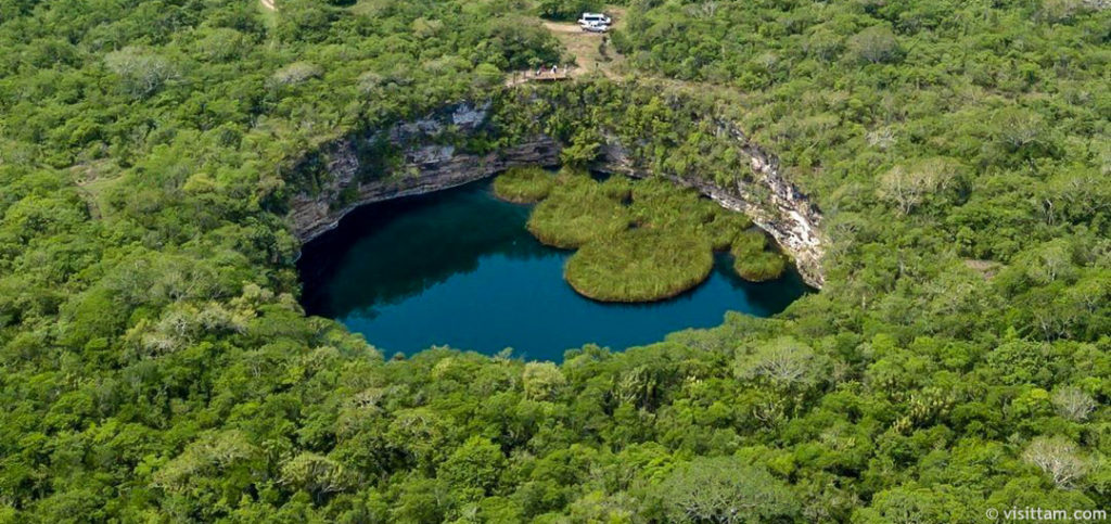
This sinkhole (cenote) is the deepest on Earth at ~335 metres. The depth of El Zacatón was only found out recently due to a NASA-funded robot test to see how they would act in future missions, such as at Jupiter’s moon Europa. Typically sinkholes form due to dissolving of “soft” rock like limestone by groundwater, until eventually the underground holes become so large that the ceiling caves in. However, this one is a bit different in that nearby volcanic activity has increased the local water temperatures (average ~ 30°C) and acidity, as well making the waters more sulfurous and rich in minerals. Another neat thing about the sinkhole here is the floating grass islands, which are made of travertine (calcium carbonate).
Visiting Zacatón sinkhole?
There are road that you can drive (and some tours) leading from the small towns nearby to the sinkholes in the area. While Zacatón itself cannot be swam in (only observed from a distance), there are many other sinkholes in the area more inviting to visitor (and well as on the Yucatán Peninsula in Mexico).
#19 & #20. Famous mountain ranges

Ok, this is kind of a cheat “grab-bag” for the last 2 spots on the list… however, I love mountain ranges and there are many impressive mountains out there that deserve a spot on the list. In fact, I could probably make an entire list of just mountains! But for now I’ll just devote these last 2 spots to 4 mountain ranges as an ode to the mountains. Most of these mountain ranges have all formed by slow but powerful forces when tectonic plates of the Earth collide against each other. The result of these collisions are uplift, thrusting and folding of the rocks high above ground, leading to the most impressive mountain ranges in the world!
The Alps* in Europe (famous mountain = Matterhorn)

The Alps formed via the collision of the African and the Eurasian plates ~ 55 millions year ago. This collision uplifted and exposed what was once a shallow sea bed. In many of the mountain faces you can see beautiful folded rocks. But probably the most famous and impressive looking mountain here is the Matterhorn in Switzerland.
The Himalayas in Asia (famous mountains = Everest & K2)

The Himalayas formed via the high-speed collision (in plate tectonic terms… so a few centimetres per year) of the Indian plate with the Eurasian plate. This happened around 40 millions year ago (but the actual rocks are much older). Of course, this has led to the tallest mountain peaks in the world. The most famous and impressive looking mountains here are Everest (at 8,848 m) and K2 (at 8,611 m) in Nepal.
The Andes* in South America (famous mountain spot = Torres del Paine)

The Andes are the longest mountain chain the world. They formed due to the constant subduction of the Pacific oceanic plate underneath the South America plate. This led to many high mountains, well-endowed copper deposits and active volcanoes. Some of the most stunning and picturesque mountains are in Patagonia and the Torres del Paine national park in Chile and Argentina.
The Rocky Mountains* in North America (famous mountain spots = Banff & Jasper)

The Rocky Mountains are an impressive mountain range that has been carved and shaped extensively by glaciation. They are made of very old rocks which have been uplifted and thrusted high on the mountains around 80 to 55 million years ago. Some of the most visited and stunning mountain spots are in the Banff and Jasper national parks in BC and Alberta, Canada.
Thanks for reading! Any nominations? I would love to hear about any cool geological places you think should have made the list, or if you have been to any of the ones above (or below in the extended list). Please leave a comment here, or connect with me on Twitter (@stephsykora) or Instagram (@stephaniesykora)
The extended list (almost made it):
Dinosaur Provincial Park (Alberta, Canada); Great Blue Hole (Belize); Marble Caves (Chile); Zion National Park (Utah, U.S.A.); Black Canyon of the Gunnison (Colorado, U.S.A.); Devil’s Tower (Wyoming, U.S.A.); Carlsbad Caverns (New Mexico, U.S.A.); Vinicuna Rainbow Mountain (Perú); Karijini National Park (WA, Australia); Mount Bromo (Indonesia); Chocolate Hills (Philippines); Sharks Bay (Australia); Marble Bar (W.A., Australia); Milford Sound (New Zealand); Pamukkale (Turkey); Pulpí crystal cave (Spain); White Cliffs of Dover (United Kingdom); The Dolomites (Italy); The Pyrenees (Spain); Mt. Vesuvius (Italy); Pompeii (Italy); Zumaia (Spain); Zhangye National Geopark (China); Mt. Fuji (Japan); The Door to Hell (Turkmenistan); Mt. Kilimanjaro (Tanzania); Great Rift Valley (Kenya); Dallol (Ethiopia)


[…] Cascades form a crucial segment of the Pacific Ring of Fire, a 25,000-mile horseshoe of intense seismic activity encircling the Pacific Ocean. This positioning […]
[…] example, released steam plumes in 1975. The geological history here spans millions of years, with older rocks dating back 40 million years but continuous formation still happening […]
hey the taal volcano in the philippines is a good place to visit its a big tourist attraction and you can swim in its lava lake during less active periods i have been when i lived in manila also looks amazing from an arial view
Hey! Thanks for the comment and letting me know. Sound very neat, I’ll keep it in mind of the updated geo wonders list!
[…] Giant’s Causeway walking felt like going to a location in Northern Ireland from a movie that was fantasy-themed. The […]
[…] rock formations and tranquil lagoons, providing a dynamic backdrop for photographers. The unique geological features, including Hole-in-the-Rock, offer excellent opportunities for creative compositions. Whether at […]
[…] read more about incredible geological formation on ExploringTheEarth.com . Find that article form here.And Read more like this form […]
[…] counterpart, are a geologist's and collector's dream. These ancient deposits are teeming with geological wonders that predate even the oldest bourbon barrel, promising a unique form of treasure […]
[…] In the realm of volcanic exploration, the Jaggar Observation Center stands as a bastion of knowledge and discovery. However, its availability to the public is intertwined with a nuanced dance of temporary closures and revitalizing strides. Recent times have witnessed a dynamic interplay between moments of closure, often prompted by the capricious nature of volcanic activity and the whims of weather patterns, and the subsequent unveiling of reopened doors, inviting inquisitive souls to bear witness to the island’s geological marvels. […]
[…] essence, the Big Island in Lake Erie is not merely a geographical wonder; it’s a playground for outdoor enthusiasts and nature lovers alike. Its diverse recreational […]
[…] https://exploringtheearth.com/2020/09/02/20-geological-wonders-of-the-world/ […]
[…] Grand Canyon isn’t just a geological wonder; it’s also a sanctuary for diverse wildlife. Describe the excitement of encountering […]
[…] provide researchers with a comprehensive view of the landscape, aiding in the identification of unique geological features and […]
[…] The stunning vistas and unique geological features of White Rock Overlook make it a paradise for photographers. Capture the play of light and shadow […]
[…] to be transported to the enchanting heights of Haleakala as we embark on an exploration of its geological marvels, cultural significance, and the thrilling experiences it offers to those who dare to venture its […]
[…] Lawrence River and Niagara Falls add to the region’s splendor. The Great Lakes region is a geographical wonder waiting to be […]
Looking forward to reading more of your blog posts in the future and Learn about the unique qualities of granite, marble, quartzite, and limestone, and explore the stunning Granite Marble Columbus collection by Mont Surfaces.
[…] for Exploring Geological Landmarks […]
[…] not be the first state on your travel list, but it should be. With its breathtaking natural beauty, unique geological formations, and endless outdoor activities, Utah offers a memorable vacation experience for all types of […]
[…] Devil’s Garden is a unique geological feature located in the remote wilderness of the Florida Panhandle. This natural wonder is a must-see for […]
[…] 500 million years ago, and Uluru is said to have formed as a result. This is one of the most important geological sites in the world due to its size, creation, and material. Every year, millions of people visit the […]
[…] are incredible and fascinating geological features of our planet. The magma, which rises to the Earth’s surface, causes this formation. Magma is […]
[…] is one of the most unique planets in our solar system because of its unique geological composition. Its primary colors are a combination of brown, yellow, white, orange, and everything in between. […]
In India, according to my observations . Following two sites may be included in the list of wonders :
1 Rahilo in Gujarat where well preserved dinosaur eggs and clutches are found in Cretaceous sequence .
2 . The Rajmahal Hills , Jharkhand : Atleast 12 to 15 lava flows interbedded with intertrappean sedimentary beds contain classically preserved Upper Gondwana Ptilophyllum flora . These fossils are preserved within lower 4 to 5 intertrappean beds .
So many natural wonders!
Another candidate to consider is Folded Mountain in northern BC!
https://www.alamy.com/folded-mountain-northern-rocky-mountains-near-muncho-lake-provincial-image5055576.html
Hi Jeff. Yes indeed, I need to make another list I think, just for mountains, haha! This is beautiful, I guess I do have the Rockies in my grab-bag mountains spot, but these folds at Muncho Lake are definitely a sight to see 🙂 Thanks for the comment and sharing, cheers! -Stephanie
I really loved Yosemite and Yellowstone National Parks. I don’t know if this would really deserve a spot on your list, but another fun one is Craters of the Moon National Park in Idaho. It doesn’t really look like the Moon, in my opinion, but it is a very strange and interesting place.
Nice, yes I haven’t been to Yellowstone yet, but Yosemite was beautiful when I visited. Ah, I don’t think I’ve heard of the Craters of the Moon, but from looking online it does seem like a strange place. I’ll have to read more about it! Though I have so many North American places already I need to be careful not too be too North American biased… that or just make another list, haha. Cheers 🙂
The previous reply should be a pointer to do this again in a year’s time to show an updated version of the amazing geology in the world. So hard to do a best-of, but there you go…;..
Hey Fraser. Yeah, it is tough to pick just 20, or any sort of best-of list. I tried to avoid using the words “top 20” as I know there can be lots of arguments, but instead just presented 20 cool sites 🙂 And I agree, I think I will do an update to this list in the near future as I get more suggestions and find out about more places (as mentioned, it definitely is biased with what I am familiar with, but I’m sure there are lots of places I either don’t know about or forgot to include). Thanks for reading, cheers!
One very striking rock formation is missing. Ever heard of “Pip’s Rock”? The cliff face shows a prime example of rocks laid down during the Snowball Earth Era (Either Sturtian or Marinoan). It is located in Namibia. One of the most stunning sites to behold on our beautiful, divinely created, planet, mother Earth. Track Paul Hofmann’s theory. The implications are mind blowing.
Hey Siem. Yes, good point, I think I know the one you are talking about (we did study the Snowball Earth theory at university, but I must have forgot the name of it). That’s definitely a good one and very significant geologically. If/when I do an update to the list I should include Pip’s Rock and the Snowball Earth significance for sure. Thanks for the suggestion 🙂