
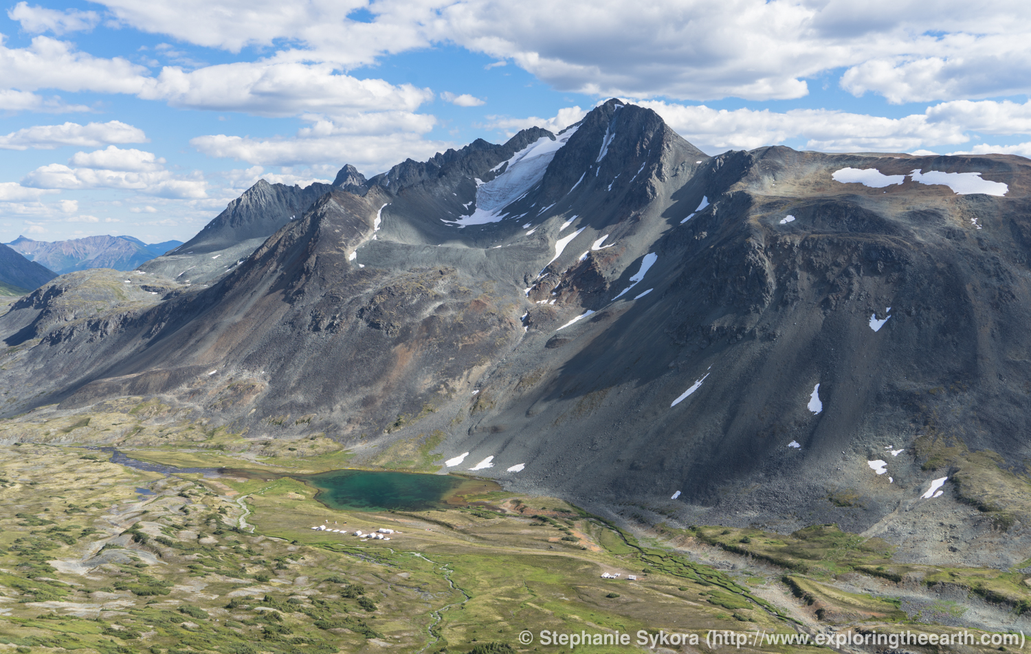
The North. Well, not THAT north, just northern BC, but still, a place that is rugged, wild and stunning. Sharp mountain peaks silhouette the horizon with sides so steep that only mountain goats can climb, and maybe the occasional craz… er, “brave” geologist. Recently I found myself returning to my home country and province of British Columbia, Canada. And indeed, I missed the mountains (no offense Australia)!
I was part of an exploration campaign that consisted of rock and soil sampling, as well as some detailed geological mapping. In this post I’ll share some insights to what working in northern BC is like, as well as a little intro to why the north looks the way it does (hint, it is a combination of rocks (geology) and ice (glaciers)).

British Columbia Rocks (Geology)
Western North America (i.e., British Columbia, Yukon and Alaska) all belong to what is called the North American Cordillera. This was (in very simplified sense) a series of island arcs that accreted onto ancestral North America hundreds of millions of year ago (cf. Bond and Kominz, 1984; Nelson and Colpron, 2007; Johnston, 2008).
BC in particular can be furthered simplified and classified into 5 “morphogeologic” belts (e.g., Gabrielse et al., 1991; Monger and Price, 2002). These belts are defined by distinct land forms, rock types, metamorphic grades and structural styles, with most of the “action” taking place during the Mesozoic (i.e., ~ 250 to 65 million year ago). They are from east to west:

- Foreland Belt = sedimentary rocks deposited on/nearby ancestral North America that have been thrusted and folded (e.g., Rocky, Mackenzie and Franklin mountains)
- Omineca Belt = dominantly high-grade metamorphic rocks formed during collision and accretion of ancestral Northern America (e.g., Purcell, Cariboo, Omineca and Selwyn mountains)
- Intermontane Belt = volcanic and sedimentary rocks formed dominantly in island arcs ~ 200 million years ago (e.g., Stikine, Interior plateaus, Skeena mountains)
- Coast Belt = massive granitic and lesser metamorphic rocks that formed 50 to 200 mya (e.g., Coast, Cascade mountains)
- Insular Belt = volcanic and sedimentary rocks dominantly, with clastic accretionary complexes and lesser intrusions (e.g., Insular Mountains, the continental shelf).
If you want to check out a detail geological map of BC and the rest of Canada, check out the Geological Survey of Canada’s map or the British Columbia Geological Survey’s website.

Northern B.C.
The mountains in northern BC (more specifically, northeastern BC) were once part of an island arc, similar to modern-day Japan. This was during the Mesozoic time period, approximately 200 million year ago. The island arcs were accreted to continental North America, along with some dramatic deformation such as oroclinial bending, and now are known as the Quesnellia and Stikinia Terrane. These are two main former island arcs that compose northern BC and host younger plutonic rocks as well as significant mineral deposits (i.e., porphyry Cu-Au-Mo deposits; Nelson and Colpron, 2007).

Thus, the mountains I was exploring within in northern BC now are ancient volcanic terranes. While there have been multiple periods of intense glacial and ice ages in the distant past, about 17,000 to 14,000 years ago was the last glacial maximum where most of BC is thought to have been glaciated (Hebda, 2007). This dramatically shaped the land, forming the broad U-shaped valleys, jagged mountain horns, cirques and arêtes, as well as many other features.


Exploration
When we are doing early stage exploration it usually consists of a lot of walking and thinking… with very little to no impact on the environment (besides a few chips off some rocks). Hiking around the mountains you gather information like rock types, structures, mineralization (minerals that may contain copper or gold), and alteration (i.e., changes in the minerals of the rocks due to the interaction of a hydrothermal fluids (i.e., hot, chemically distinct fluids that may or may not have carried metals)).
We sample the rocks and send them away for analysis in a laboratory in order to get data on what elements are in the rocks, which can help us understand them more than just based on field observations. But having both together is key. If the area is covered by thick soils, vegetation or glacial till then we can collect soil samples and analyze that too, as it partially pick up the signature of what the rocks are beneath.
There are many other tools to use in early stage exploration. A common one is to run a geophysical survey which is also non-destructive and uses fancy/not-so-fancy equipment to gather physical information of beneath the surfaces to help us understand the area in a more 3-D sense, as well as to see if there is anything interesting beneath the surface that we can’t see (e.g., large magnetic bodies or chargeable areas which might indicate metal-bearing sulfide minerals).

Early stage exploration is also about working with the local land owners, the local first nations and making sure there is little impact on the environment. If something is found then it goes to the next stage, but carrying forward the same principles for best practices.

Final thoughts
British Columbia is a pretty amazing place (of course, no personal bias here…). Yes, it can be tough logistically to get up there in northern BC, (and the weather can be pretty horrible at times, and the field season in very short, and there are grizzly bears to watch out for), but the geology is very fascinating. It was very neat to be able to understand the rocks and landscape just a bit better with exploration and applied science up north in a rugged and underexplored area.
– Stephanie

Thanks for reading! Please subscribe for more posts via email, and/or leave a comment, share this post, or follow me on Twitter (@stephsykora) or Instagram (@stephaniesykora)


Appreciatee you blogging this
Just returned from my first visit to Telegraph Creek. Recently discovered my parentage and wanted to see where I come from. Now I want to study geology in order to greater understand this magic land. You say islands, I saw evidence of the sea everywhere. We live in Oregon, but never saw mountains and gorges until traveling through BC.
Hi Tanya. Yes it truly is a spectacular place, glad it inspired you 😉 Thanks for the comment and stumbling upon my blog. Cheers, Stephanie.
These are attractive scenaries
Thanks. I enjoyed this, especially since I want to visit the mountains of BC …
Thank you! Yeah the mountains in BC are my favorite, I missed them from living abroad in Australia so it was nice to be back and see them. Hopefully you can get to visit them one day too 🙂
Cheers,
Stephanie
Loved this one! Beautiful! Closest I’ve ever come to this was hiking across the Teton range in Wyoming once. Have been to southern BC several times (Vancouver) but never close to up here.
Thanks Pete! Yeah the northern mountains in BC are truly amazing. I have never been to the Teton range, but the mountains there also look quite stunning. Most people go to southern BC as it is pretty remote up north and not a lot of accessibility, but definitely still possible. Thanks again for reading and following along with my blog, cheers 🙂
-Stephanie
I love reading your blog. I don’t necessarily understand all the terminology but I find it very interesting. Now that you are back on home turf, welcome back, and showing and describing our part of the world it certainly explains how we were made…the land and rocks that is.
I also was so interested in the Australia bit as It has become my second home away from home!
Happy travels young lady! I’m trying to keep up with that aunt of yours searching out her Marco Polo roots….such fun! Thanks for the interesting read!
Hi Sandy,
Thank you very much 🙂 Glad you find it interesting, and yeah sorry for some of the terminology, I try to keep it simple but some words you just can’t avoid in geology, haha. Glad to be back in Canada, but I will be returning to Australia soon, it is also my second home country now. And yes their Marco Polo journey seems to be quite fun so far! Thanks again for reading and following along, cheers 🙂
Stephanie