The last part of my geology of Iceland blog series ventures from the centre to the south of the island. These areas contain the youngest rocks in Iceland (Nornahraun 2014/15 lava field), glacier-covered volcanoes (Vatnajökull), geothermal altered mountains (Landmannaluagar) and the scar of one of the most violent eruptions ever (Laki)!

This post is part 3 of 3 in my series “How to explore Iceland through the eyes of a geologist” which is based on the field trip to Iceland that I co-organized as part of our university’s SEG student chapter. For an intro to the geology and tectonic setting of Iceland, check out my first post here and my second post here.

Iceland, Geology, Travel, Volcanoes, Volcano, Lava, Plate Tectonics, Geologist, Landscape, Explore, Outdoors, Nature, Earth Science, Science, Geoscience, Photography, Adventure, Field Trip, Guide, Formation, Map, Location, North American Plate, Eurasian Plate, Rift, Mid-Atlantic Ridge, Geology map, Map
Areas outlined in my 3-part blog post series “How to explore Iceland through the eyes of a geologist”

Part 3: Glaciers and Volcanoes of the South

There are some pretty hairy river crossings when traveling through the centre of Iceland. The main road is F88 and requires a 4-wheel drive vehicle… and a bit of courage. These roads are also frequently closed due to floods and bad conditions, so make sure to check ahead of time if it’s good to go.

Iceland, Geology, Travel, Volcanoes, Volcano, Lava, Plate Tectonics, Geologist, Landscape, Explore, Outdoors, Nature, Earth Science, Science, Geoscience, Photography, Adventure, Field Trip, Guide, Formation, Map, Location, North American Plate, Eurasian Plate, Rift, Mid-Atlantic Ridge, geotourism, ice, fire, Bárðarbunga, Iceland volcano, island, glacier, ice cap, Vatnajökull, Eyjafjallajökull, europe, highlands, river crossing, 4x4, F88
River crossing on the F88 road, on the way to the central highlands area of Iceland.

Holuhraun (aka. Nornahraun) lava field

The most recent eruption in Iceland was part of the 190 km long Bárðarbunga volcanic system, located in the rift zone part of the Eastern Volcanic Zone. One third of the volcanic system lies below the Vatnajökull ice cap. On August 16th 2014, intense earthquake swarms associated with magmatic activity and deformation were detected at the Bárðarbunga system (Sigmundsson et al., 2014). Over the next 13 days dykes propagated 45 km northeast to the Holuhraun lava field where it breached the surface and formed a small 4 hour effusive eruption (Dumont et al., 2015). A couple days later, more intense gas-rich eruptions started and continued until February 27th 2015. What remains now is a tholeiite basalt lava field that is more than 84 km2. Textures of the lava vary from ʻaʻā to slabby pāhoehoe (Lavallee et al., 2015).

Iceland, Geology, Travel, Volcanoes, Volcano, Lava, Plate Tectonics, Geologist, Landscape, Explore, Outdoors, Nature, Earth Science, Science, Geoscience, Photography, Adventure, Field Trip, Guide, Formation, Map, Location, North American Plate, Eurasian Plate, Rift, Mid-Atlantic Ridge, geotourism, ice, fire, Bárðarbunga, Holuhraun, Nornahraun, 2015 eruption, Iceland volcano
The Bárðarbunga volcanic system (Jóhannesson and Sæmundsson, 1998)
Iceland, Geology, Travel, Volcanoes, Volcano, Lava, Plate Tectonics, Geologist, Landscape, Explore, Outdoors, Nature, Earth Science, Science, Geoscience, Photography, Adventure, Field Trip, Guide, Formation, Map, Location, North American Plate, Eurasian Plate, Rift, Mid-Atlantic Ridge, geotourism, ice, fire, Bárðarbunga, Holuhraun, Nornahraun, 2015 eruption, Iceland volcano
Steam from the contact of the Holuhraun lava field with a river at the Bárðarbunga volcanic system, Iceland
Iceland, Geology, Travel, Volcanoes, Volcano, Lava, Plate Tectonics, Geologist, Landscape, Explore, Outdoors, Nature, Earth Science, Science, Geoscience, Photography, Adventure, Field Trip, Guide, Formation, Map, Location, North American Plate, Eurasian Plate, Rift, Mid-Atlantic Ridge, geotourism, ice, fire, Bárðarbunga, Holuhraun, Nornahraun, 2015 eruption, Iceland volcano
Walking over the Holuhraun lava field of the Bárðarbunga volcanic system, Iceland
Iceland, Geology, Travel, Volcanoes, Volcano, Lava, Plate Tectonics, Geologist, Landscape, Explore, Outdoors, Nature, Earth Science, Science, Geoscience, Photography, Adventure, Field Trip, Guide, Formation, Map, Location, North American Plate, Eurasian Plate, Rift, Mid-Atlantic Ridge, geotourism, ice, fire, Bárðarbunga, Holuhraun, Nornahraun, 2015 eruption, Iceland volcano
ʻAʻā texture of the Holuhraun lava field of the Bárðarbunga volcanic system, Iceland

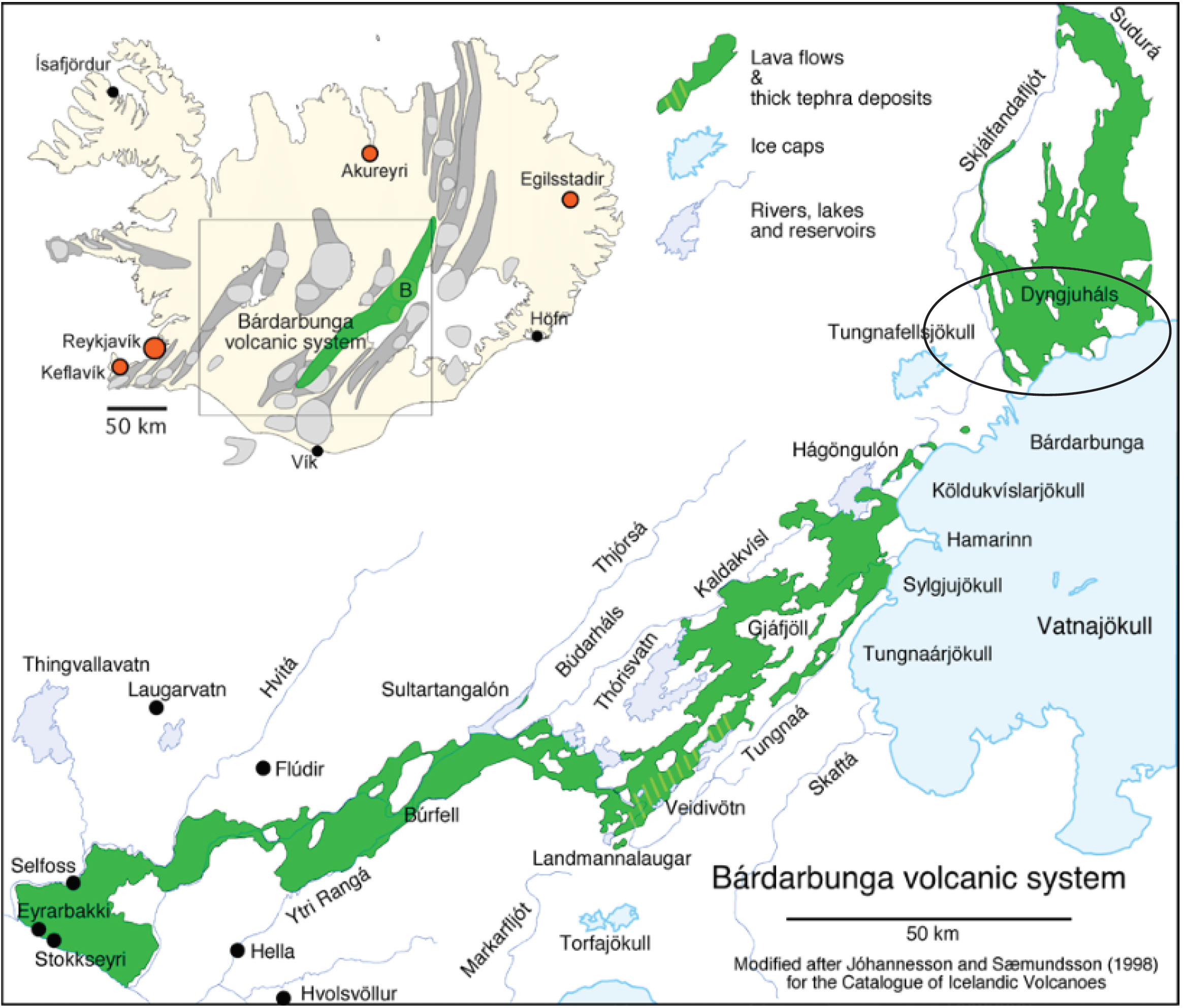
The volcanic eruption also produced large amounts of wind-spun, thread-like tephra known as Pele’s hair. In Icelandic, Pele’s hair is known as Nornahár, which means “witches’ hair”, and thus the new official name of the lava field is Nornahraun or “witches’ lava” (Thordarson, 2015).

Iceland, Geology, Travel, Volcanoes, Volcano, Lava, Plate Tectonics, Geologist, Landscape, Explore, Outdoors, Nature, Earth Science, Science, Geoscience, Photography, Adventure, Field Trip, Guide, Formation, Map, Location, North American Plate, Eurasian Plate, Rift, Mid-Atlantic Ridge, geotourism, ice, fire, Bárðarbunga, Holuhraun, Nornahraun, 2015 eruption, Iceland volcano, pele's hair, nornahar
Pele’s hair, known as Nornahár in Icelandic, which means “witches’ hair”, Holuhraun lava field of the Bárðarbunga volcanic system, Iceland
Iceland, Geology, Travel, Volcanoes, Volcano, Lava, Plate Tectonics, Geologist, Landscape, Explore, Outdoors, Nature, Earth Science, Science, Geoscience, Photography, Adventure, Field Trip, Guide, Formation, Map, Location, North American Plate, Eurasian Plate, Rift, Mid-Atlantic Ridge, geotourism, ice, fire, Bárðarbunga, Holuhraun, Nornahraun, 2015 eruption, Iceland volcano, geothermal, island
People walking in the geothermal water from the contact of the Holuhraun lava field with a river, Bárðarbunga volcanic system, Iceland

Ice caps and glaciers

Heading south through the interior of Iceland reveals amazing glaciers and ice caps. The largest glacier, which covers a fair bit of Iceland, is called Vatnajökull. Two of the other large glaciers are Mýrdalsjökull and Eyjafjallajökull. Active volcanoes are often underneath these ice caps. Eyjafjallajökull (a tongue twister of a name to pronounce), for example, is where the infamous 2010 eruption occurred. This dispersed volcanic ash into the atmosphere which eventually reached Europe and caused a shut down in air traffic for a week! Recently there have been reports on some rumbling at the even larger neighboring Katla volcano…

Iceland, Geology, Travel, Volcanoes, Volcano, Lava, Plate Tectonics, Geologist, Landscape, Explore, Outdoors, Nature, Earth Science, Science, Geoscience, Photography, Adventure, Field Trip, Guide, Formation, Map, Location, North American Plate, Eurasian Plate, Rift, Mid-Atlantic Ridge, geotourism, ice, fire, Bárðarbunga, Iceland volcano, island, glacier, ice cap, Vatnajökull, Eyjafjallajökull, Katla, 2010 eruption, air traffic, europe
Vatnajökull ice cap in the highlands region of Iceland. it extends as far as the eye can see, and kinda looks like a sea too… from a distance 😉
Iceland, Geology, Travel, Volcanoes, Volcano, Lava, Plate Tectonics, Geologist, Landscape, Explore, Outdoors, Nature, Earth Science, Science, Geoscience, Photography, Adventure, Field Trip, Guide, Formation, Map, Location, North American Plate, Eurasian Plate, Rift, Mid-Atlantic Ridge, geotourism, ice, fire, Bárðarbunga, Iceland volcano, island, glacier, ice cap, Vatnajökull, Eyjafjallajökull, Katla, 2010 eruption, air traffic, europe, highlands
An outlet glacier from the Vatnajökull ice cap, in the central highlands area of Iceland

Further along south is the 8 km long Sólheimajökull temperate outlet glacier, which descends from ~ 1500 m at its parent glacier Mýrdalsjökull, to ~ 100 m elevation (Russell et al., 2010).

Iceland, Geology, Travel, Volcanoes, Volcano, Lava, Plate Tectonics, Geologist, Landscape, Explore, Outdoors, Nature, Earth Science, Science, Geoscience, Photography, Adventure, Field Trip, Guide, Formation, Map, Location, North American Plate, Eurasian Plate, Rift, Mid-Atlantic Ridge, geotourism, ice, fire, Bárðarbunga, Iceland volcano, island, glacier, ice cap, Vatnajökull, Eyjafjallajökull, Katla, 2010 eruption, air traffic, europe, highlands
Sólheimajökull temperate outlet gla­cier, south Iceland

Landmannalaugar

Landmannalaugar (yet another one of these Icelandic names that are a mouthful to pronounce), is a geothermally active area in Iceland know for its amazing colourful mountains. Whereas most of Iceland is composed of mafic rocks, the Landmannalaugar area (i.e., within the Torfajökull central volcanic complex) has the most silicic rocks in Iceland. It has been active for ~ 1 million years, and more than 250 km3 of rhyolite has been erupted in numerous, mostly sub-glacial eruptions (Sæmunds­son, 1972; McGarvie, 1985). An example of one of the rhyolitic mountains is Bláhnjúkur. Bláhnjúkur formed by a sub-glacial rhyolitic eruption, which overlaid older rhyolite.

Iceland, Geology, Travel, Volcanoes, Volcano, Lava, Plate Tectonics, Geologist, Landscape, Explore, Outdoors, Nature, Earth Science, Science, Geoscience, Photography, Adventure, Field Trip, Guide, Formation, Map, Location, North American Plate, Eurasian Plate, Rift, Mid-Atlantic Ridge, geotourism, ice, fire, Bárðarbunga, Iceland volcano, island, glacier, ice cap, Vatnajökull, Eyjafjallajökull, europe, highlands, F88, south iceland, Landmannalauger, silica, geothermal, hydrothermal, alteration
Landmannalaugar mountains in southern Iceland
Iceland, Geology, Travel, Volcanoes, Volcano, Lava, Plate Tectonics, Geologist, Landscape, Explore, Outdoors, Nature, Earth Science, Science, Geoscience, Photography, Adventure, Field Trip, Guide, Formation, Map, Location, North American Plate, Eurasian Plate, Rift, Mid-Atlantic Ridge, geotourism, ice, fire, Bárðarbunga, Iceland volcano, island, glacier, ice cap, Vatnajökull, Eyjafjallajökull, europe, highlands, F88, south iceland, Landmannalauger, silica, geothermal, hydrothermal, alteration, glacier, snow
Driving toward Landmannalaugar, Iceland
Iceland, Geology, Travel, Volcanoes, Volcano, Lava, Plate Tectonics, Geologist, Landscape, Explore, Outdoors, Nature, Earth Science, Science, Geoscience, Photography, Adventure, Field Trip, Guide, Formation, Map, Location, North American Plate, Eurasian Plate, Rift, Mid-Atlantic Ridge, geotourism, ice, fire, Bárðarbunga, Iceland volcano, island, glacier, ice cap, Vatnajökull, Eyjafjallajökull, europe, highlands, F88, south iceland, Landmannalauger, silica, geothermal, hydrothermal, alteration
Bright colours on the geothermally altered Landmannalaugar mountains, southern Iceland

The Námshraun lava flow at Landmannalaugar is an interesting mixed compositions lava flow. It is a rhyolite-basalt composition, volumetrically dominated by metaluminous rhyolite, with sub-decimetre scale inclusions of icelandite and basaltic icelandite, which may have increased the temperature of the original magma and influenced its rheology (Wilson et al., 2007).

Iceland, Geology, Travel, Volcanoes, Volcano, Lava, Plate Tectonics, Geologist, Landscape, Explore, Outdoors, Nature, Earth Science, Science, Geoscience, Photography, Adventure, Field Trip, Guide, Formation, Map, Location, North American Plate, Eurasian Plate, Rift, Mid-Atlantic Ridge, geotourism, ice, fire, Bárðarbunga, Iceland volcano, island, glacier, ice cap, Vatnajökull, Eyjafjallajökull, europe, highlands, F88, south iceland, Landmannalauger, silica, mixed composition, Námshraun
Námshraun lava flow entering the lake at Landmannalaugar, Iceland
Iceland, Geology, Travel, Volcanoes, Volcano, Lava, Plate Tectonics, Geologist, Landscape, Explore, Outdoors, Nature, Earth Science, Science, Geoscience, Photography, Adventure, Field Trip, Guide, Formation, Map, Location, North American Plate, Eurasian Plate, Rift, Mid-Atlantic Ridge, geotourism, ice, fire, Bárðarbunga, Iceland volcano, island, glacier, ice cap, Vatnajökull, Eyjafjallajökull, europe, highlands, F88, south iceland, Landmannalauger, silica, mixed composition, Námshraun, rhyolite-basalt, rhyolite, basalt
Close up of the mixed composition (i.e., rhyolite-basalt) Námshraun lava flow at Landmannalaugar, Iceland
Iceland, Geology, Travel, Volcanoes, Volcano, Lava, Plate Tectonics, Geologist, Landscape, Explore, Outdoors, Nature, Earth Science, Science, Geoscience, Photography, Adventure, Field Trip, Guide, Formation, Map, Location, North American Plate, Eurasian Plate, Rift, Mid-Atlantic Ridge, geotourism, ice, fire, Bárðarbunga, Iceland volcano, island, glacier, ice cap, Vatnajökull, Eyjafjallajökull, europe, highlands, F88, south iceland, Landmannalauger, silica, mixed composition, Námshraun, rhyolite-basalt, rhyolite, basalt, moss
Neat Icelandic moss growing over the mixed composition (i.e., rhyolite-basalt) Námshraun lava flow at Landmannalaugar, Iceland

Laki

Laki is one of the most impressive sites in Iceland. Here remains the preserved scar that really gives you a sense of how destructive these volcanic eruptions can be. The Laki fissure eruption happened over an 8 month period in 1783 to 1784. It occurred along ten en-echelon fissure segments that opened toward the northeast to form a 27 km long cone row. There were over 140 eruption sites which include scoria cones, spatter cones, and tuff cones. The most common features are the scoria cones (40 to 120 m high) which consist of several thick (2 to 15 m) scoria fall layers, and capped by a thin (0.5 to 1.5 m ) spatter layer (Thordarson and Self, 2003).

Iceland, Geology, Travel, Volcanoes, Volcano, Lava, Plate Tectonics, Geologist, Landscape, Explore, Outdoors, Nature, Earth Science, Science, Geoscience, Photography, Adventure, Field Trip, Guide, Formation, Map, Location, North American Plate, Eurasian Plate, Rift, Mid-Atlantic Ridge, geotourism, ice, fire, Bárðarbunga, Iceland volcano, island, glacier, ice cap, Vatnajökull, Eyjafjallajökull, europe, highlands, F88, south iceland, Laki, Laki fissure, , basalt, Eldgjá, violent eruption, Iceland historic eruption, fissures, map
Geological map of the Laki cone row and surrounding lava flow field (from Hamilton et al., 2010)
Iceland, Geology, Travel, Volcanoes, Volcano, Lava, Plate Tectonics, Geologist, Landscape, Explore, Outdoors, Nature, Earth Science, Science, Geoscience, Photography, Adventure, Field Trip, Guide, Formation, Map, Location, North American Plate, Eurasian Plate, Rift, Mid-Atlantic Ridge, geotourism, ice, fire, Bárðarbunga, Iceland volcano, island, glacier, ice cap, Vatnajökull, Eyjafjallajökull, europe, highlands, F88, south iceland, Laki, Laki fissure, , basalt, Eldgjá, violent eruption, Iceland historic eruption, fissures
Overview of the Laki fissures from the 1783/84 eruption, Iceland
Iceland, Geology, Travel, Volcanoes, Volcano, Lava, Plate Tectonics, Geologist, Landscape, Explore, Outdoors, Nature, Earth Science, Science, Geoscience, Photography, Adventure, Field Trip, Guide, Formation, Map, Location, North American Plate, Eurasian Plate, Rift, Mid-Atlantic Ridge, geotourism, ice, fire, Bárðarbunga, Iceland volcano, island, glacier, ice cap, Vatnajökull, Eyjafjallajökull, europe, highlands, F88, south iceland, Laki, Laki fissure, , basalt, Eldgjá, violent eruption, Iceland historic eruption, fissures
…and one with me 😉 Overview of the Laki fissures from the 1783/84 eruption, Iceland

The Laki eruptions were the second largest basaltic lava flow in historic times. It produced 10 to 13 km high columns of volcanic ash and SO2 that dispersed into the westerly polar jet steam that was then dispersed over Europe. The sulfur emissions casted a veil over Europe and caused climate perturbations, including a drop in temperature of 1.3°C for 2 to 3 years (Thordarson and Self, 2003). The noxious fumes emitted by the eruption also stunted grass growth and killed more than half of the livestock in Iceland through fluorine poisoning. The consequences ultimately resulted in the disastrous ‘Haze Famine’ that killed 20% (10,000 folks) of the Icelandic human population (Thordarson and Hoskuldsson, 2002).

Iceland, Geology, Travel, Volcanoes, Volcano, Lava, Plate Tectonics, Geologist, Landscape, Explore, Outdoors, Nature, Earth Science, Science, Geoscience, Photography, Adventure, Field Trip, Guide, Formation, Map, Location, North American Plate, Eurasian Plate, Rift, Mid-Atlantic Ridge, geotourism, ice, fire, Bárðarbunga, Iceland volcano, island, glacier, ice cap, Vatnajökull, Eyjafjallajökull, europe, highlands, F88, south iceland, Laki, Laki fissure, , basalt, Eldgjá, violent eruption, Iceland historic eruption, fissures, moss
View from inside the Laki fissures from the 1783/84 eruption – Iceland
Iceland, Geology, Travel, Volcanoes, Volcano, Lava, Plate Tectonics, Geologist, Landscape, Explore, Outdoors, Nature, Earth Science, Science, Geoscience, Photography, Adventure, Field Trip, Guide, Formation, Map, Location, North American Plate, Eurasian Plate, Rift, Mid-Atlantic Ridge, geotourism, ice, fire, Bárðarbunga, Iceland volcano, island, glacier, ice cap, Vatnajökull, Eyjafjallajökull, europe, highlands, F88, south iceland, Laki, Laki fissure, , basalt, Eldgjá, violent eruption, Iceland historic eruption, fissures, moss, fog
Eerie moss and fog from inside the Laki fissures from the 1783/84 eruption – Iceland

South coast

Lastly along the south coast, near Vik, there is some of the most beautiful examples of columnar basalt… as well as puffins you can spot if you get lucky!

Iceland, Geology, Travel, Volcanoes, Volcano, Lava, Plate Tectonics, Geologist, Landscape, Explore, Outdoors, Nature, Earth Science, Science, Geoscience, Photography, Adventure, Field Trip, Guide, Formation, Map, Location, North American Plate, Eurasian Plate, Rift, Mid-Atlantic Ridge, geotourism, ice, fire, Bárðarbunga, Iceland volcano, island, glacier, ice cap, Vatnajökull, Eyjafjallajökull, europe, highlands, F88, south iceland, Vík, puffins, puffin, Icelandic puffins
South Iceland coast line with flying puffins, near Vík – Iceland
Iceland, Geology, Travel, Volcanoes, Volcano, Lava, Plate Tectonics, Geologist, Landscape, Explore, Outdoors, Nature, Earth Science, Science, Geoscience, Photography, Adventure, Field Trip, Guide, Formation, Map, Location, North American Plate, Eurasian Plate, Rift, Mid-Atlantic Ridge, geotourism, ice, fire, Bárðarbunga, Iceland volcano, island, glacier, ice cap, Vatnajökull, Eyjafjallajökull, europe, highlands, F88, south iceland, Vík, puffins, puffin, Icelandic puffins
Icelandic puffins at the south coast of Iceland near Vík

Some of the major waterfall in the area are Fagrifoss “beautiful falls” and Skogáfoss. Skogáfoss is sourced from both Mýrdalsjökull and Eyjafjallajökull glaciers and travels down the Skóga River (Jóhannesson and Sæmundsson, 2009). The cliffs that Skogáfoss fall over (60 m tall) represent the former shoreline of Iceland before sand-rich deposits from recent jökulhlaup (i.e., catastrophic floods) extended the islands length to the south.

Iceland, Geology, Travel, Volcanoes, Volcano, Lava, Plate Tectonics, Geologist, Landscape, Explore, Outdoors, Nature, Earth Science, Science, Geoscience, Photography, Adventure, Field Trip, Guide, Formation, Map, Location, North American Plate, Eurasian Plate, Rift, Mid-Atlantic Ridge, geotourism, ice, fire, Bárðarbunga, Iceland volcano, island, glacier, ice cap, Vatnajökull, Eyjafjallajökull, europe, highlands, F88, south iceland, Vík, Laki, Fagrifoss, waterfall
Fagrifoss “beautiful falls” – Iceland
Iceland, Geology, Travel, Volcanoes, Volcano, Lava, Plate Tectonics, Geologist, Landscape, Explore, Outdoors, Nature, Earth Science, Science, Geoscience, Photography, Adventure, Field Trip, Guide, Formation, Map, Location, North American Plate, Eurasian Plate, Rift, Mid-Atlantic Ridge, geotourism, ice, fire, Bárðarbunga, Iceland volcano, island, glacier, ice cap, Vatnajökull, Eyjafjallajökull, europe, highlands, F88, south iceland, Vík, Skogafoss, waterfall
Skógafoss falls over cliffs that represent the former shoreline of Iceland
Iceland, Geology, Travel, Volcanoes, Volcano, Lava, Plate Tectonics, Geologist, Landscape, Explore, Outdoors, Nature, Earth Science, Science, Geoscience, Photography, Adventure, Field Trip, Guide, Formation, Map, Location, North American Plate, Eurasian Plate, Rift, Mid-Atlantic Ridge, geotourism, ice, fire, Bárðarbunga, Iceland volcano, island, glacier, ice cap, Vatnajökull, Eyjafjallajökull, europe, highlands, F88, south iceland, sunrise, valley, Þakgil, thakgil
Morning sunrise in Þakgil valley in southern Iceland

Final thoughts:

Iceland’s precarious position on the Mid-Atlantic Ridge has lead to a constantly changing landscape formed from violent volcanism. This post concludes my 3-part geology series of Iceland. I hope I have shed a bit of “geological” light on this dramatic, volcanic, island country that is Iceland! Even though I covered a fair bit of ground, there is still so much more to see and explore in Iceland (hence I would love to return one day). I regard Iceland as one of the neatest places I have ever travelled to, and I reckon that anyone who travels there would have a similar feeling, whether you are a geologist or not!

-Stephanie

Table of Icelandic Geology Terms

á (s) ár (pl), fljót (large river) River
askja Caldera
aur (glacial outwash) Sandur
bergkvika Magma
berg Rock
bjarg (s), björg (pl) Cliffs/Rocks/Crags
borg (s), borgir (pl) Rocky hill
bunga Rounded hill
dalur Valley
díabas Dolerite
eldar (pl) Fires/Eruptions
eldborg (s), eldborgir (pl) Lava ring
eldgjá Lava fissure
fjall (s), fjöll (pl) Mountain
gjall Scoria
hellir Cave
hraun Lava flow
jökull Glacier
móberg Tuff/Hyaloclastite
vatn (s), vötn (pl) Lake
víti (also used for explosive volcanic craters or maars) Hell
völlur (s), vellir (pl) Field/plain

Thanks for reading! Please subscribe for more posts via email, and/or leave a comment, share this post, or follow me on Twitter (@stephsykora) or Instagram (@stephaniesykora)

Subscribe to Blog via Email

Please enter your email to subscribe for emails on new posts!