
The north of Iceland offers a young and dramatic volcanic landscape that is truly “out of this world” (you will see what I mean later). Heading northeast toward Akureyri, you enter what is known as the North Volcanic Zone (NVZ). The NVZ is a subset of the roughly north-striking rift that is pulling apart Iceland and causing volcanism. The abundant volcanism in the area has resulted in brilliant places to visit in the central north, such as Mývatn rootless cones, Dimmuborgir lava formations, Námafjall geothermal area, Krafla fires, Askja volcano, Herðubreið table mountain, and more!
This post is part 2 in the continuation of my series “How to explore Iceland through the eyes of a geologist” which is based on the field trip to Iceland that I co-organized as part of our university’s SEG student chapter. For an intro to the geology and tectonic setting of Iceland, check out my first post here.

- Part 1: A Land of Ice and Fire (Intro to Iceland, Reykjavík, the Golden Circle, Snæfellsnes Peninsula)
- Part 2: Volcanic Landscapes of the North (Mývatn, Dimmuborgir, Krafla, Námafjall, and Askja)
- Part 3: Glaciers and Volcanoes of the South (Nornahraun 2014/15 lava field, Central Highlands, Landmannaluagar, Laki, Vík)
Part 2: Volcanic Landscapes of the North
Mývatn and Skútustaðagígar
The Mývatn area is packed full of interesting geological features, most of which formed in roughly the last 2,300 year. The lake itself (Mývatn, vatn = lake in Icelandic), contains a ponded area called Skútustaðagígar, which is a natural monument due to its spotted terrain full of pseudocraters. Pseudocraters (also known as rootless cones) are volcanic landforms that resembles a true volcanic craters, but differs in that they are not actual vents from which lava erupted. They are composed of scoria, splatter and tephra and formed ~2,300 years ago when lava flowed over the lake’s water-logged sediments. This caused numerous phreatic (steam) explosions that built the series of cone (Lanagan et al., 2001; Thordarson and Hoskuldsson, 2008).


Dimmuborgir
Dimmuborgir is a place nearby Mývatn. It is known as the “dark castle”. They formed ~1,800 to 2,300 year ago, when large, ugly, means trolls were exposed to sunlight after a night of dancing and turned to stone!

… according to Icelandic folklore. Actually, the bizarre rock pillars formed because of a pooling of lava, or ‘lava lake’, over top of wet, unconsolidated sediments. Gases and steam built up underneath the lava and when the steam escaped from the underlying wet sediments, it ripped through the lava and the lava froze (or solidified) in the air, forming these chimney-like structures (Gregg and Christie, 2013). The lava lake eventually drained and collapsed, leaving neat features evident of the lava’s subsidence and retreat.


Krafla Fires
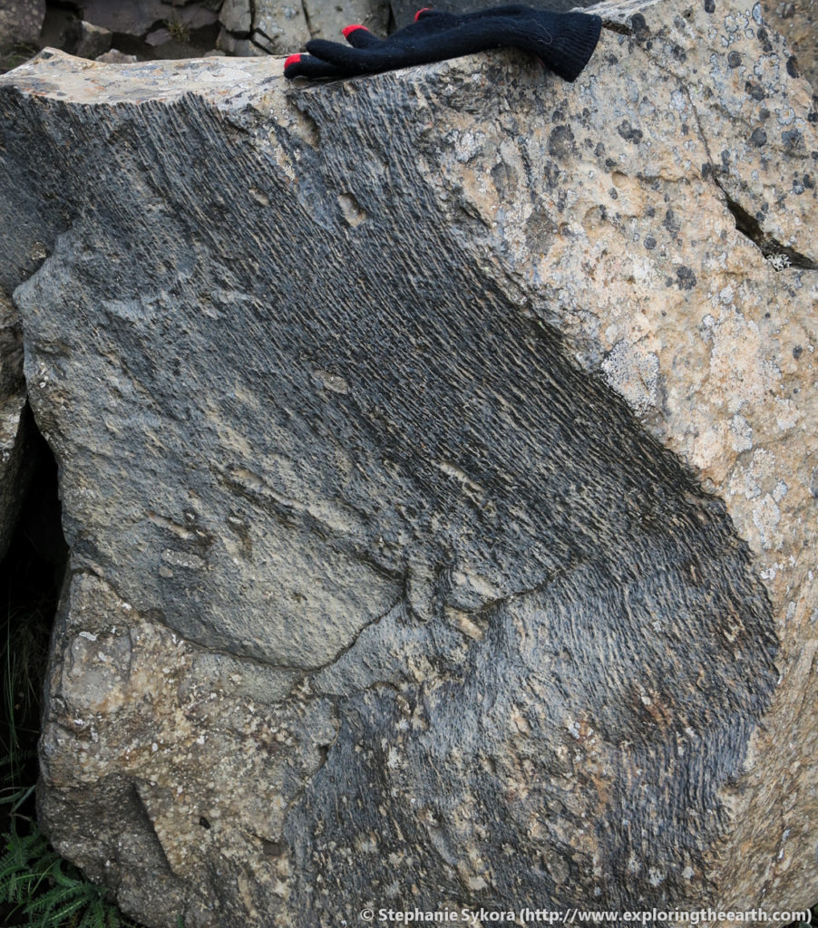
Krafla volcanic system is a major contributor to the crustal formation of Iceland. The Krafla system is part of the active Northern Volcanic Zone (NVZ), and contains fissure swarms, crater rows and normal faults surrounding a central volcano. It has been active over the past 300,000 year with 29 reported eruptions in recorded history. The most recent was the Krafla fires (fire = eruption in Icelandic) between 1975 to 1984. What remains is a stunning lava fields that is still steaming and too hot to touch in places. Here you can observe some of the complexities of how the lava flowed and formed (e.g., mini lava tubes).


Námafjall Geothermal Area
Námafjall is a high-temperature geothermal field (~250°C at 1,800 m depth; Arnorsson et al., 1978). The name Námafjall is derived from the Icelandic words meaning “mountain of mines”, due to the abundant sulphur that was historically mined from the area. Námafjall is related to the Krafla volcanic system. Boiling mud pools, steaming fumaroles and solfataras with sulfur crystals compose the yellow and beige stained landscape.

The gas from the fumaroles is steam as well as hydrogen sulfide which results in the characteristic “rotten egg” smell of the area. The waters are acid-sulphate, which comes from the gases. When you have boiling at depth, the rising gas phase can comes into cold groundwater and condense. Hydrogen sulfide and that gas can react with water to form sulfuric acid which alters the rocks and sediments of the landscape.


Lots of ‘___foss’
There are two particular waterfalls (foss = waterfall in Icelandic) in this regions that are stunning and must-sees; Goðafoss (“waterfall of the gods”) and Dettifoss (“the beast”). Beautiful columns make up the rocks they fall over. These rocks are basalt at Goðafoss, but at Dettifoss some of the rocks are icelandite (a type of andesite rock that is Fe-rich), and as you can probably guess, discovered in Iceland.


Herðubreið
Driving south from Mývatn you enter the Ódáðahraun lava desert and Herðubreiðarlindir (oasis of Herðubreið). The landscape is dominated by basaltic lava. Standing prominently in the oasis is the mountain called Herðubreið. This is a 1682 m high mountain and voted as the “Iceland national mountain”. It is known as a table mountain (tuya), which is obvious by its defining flat top. Table mountains form when a volcano erupts (effusively) beneath ice. Approximately 800 m of ice covered Herðubreið when subglacial hyaloclastite and pillowed basalt flows erupted beneath the ice, this was then capped by 300 m of subaerial lava (Thordarson and Höskuldsson, 2002).


Askja
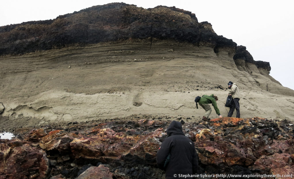
Toward the south towards the Dreki huts is the ominous Askja. The landscape surrounding it seems like it is out of this world, and infact NASA astronauts used the area to practice moon landing training. Askja is another central caldera and fissure system (like Krafla) that is located on the active NVZ. It has been active for at least 200,000 years (Sigvaldason, 2002), which increased activities between 10,000 to 4,500 years ago due to crustal rebound from deglaciation.


The most famous eruption was a violent rhyolitic “plinian-style’ (i.e., tass gas, ash and pumice-rich columns over 50 km high) eruption in 1875 A.D. This formed the Öskjuvatn caldera now filled with Öskjuvatn (vatn = lake). Visible on the rims are rare welded fall deposits, as well as marked changes from wet to dry eruption styles (Carey et al., 2008).


Final thoughts:
While it might be tricky to get to (and require a bit of 4-wheel driving), the north centre of Iceland offers spectacular landscapes and sights, that I personally think are must-sees for any adventurer in Iceland. This is truly a land shaped by young volcanism, and what remains is a diverse array of geological features to explore.
Next up in my “how to explore Iceland through the eyes of a geologist” series is Part 3 – Glaciers and Volcanic of the South. This last post will be about the central highlands and south, where the youngest rocks and massive glaciers reside!
-Stephanie
Table of Icelandic Geology Terms
| á (s) ár (pl), fljót (large river) | River |
| askja | Caldera |
| aur (glacial outwash) | Sandur |
| bergkvika | Magma |
| berg | Rock |
| bjarg (s), björg (pl) | Cliffs/Rocks/Crags |
| borg (s), borgir (pl) | Rocky hill |
| bunga | Rounded hill |
| dalur | Valley |
| díabas | Dolerite |
| eldar (pl) | Fires/Eruptions |
| eldborg (s), eldborgir (pl) | Lava ring |
| eldgjá | Lava fissure |
| fjall (s), fjöll (pl) | Mountain |
| gjall | Scoria |
| hellir | Cave |
| hraun | Lava flow |
| jökull | Glacier |
| móberg | Tuff/Hyaloclastite |
| vatn (s), vötn (pl) | Lake |
| víti (also used for explosive volcanic craters or maars) | Hell |
| völlur (s), vellir (pl) | Field/plain |
Thanks for reading! Please subscribe for more posts via email, and/or leave a comment, share this post, or follow me on Twitter (@stephsykora) or Instagram (@stephaniesykora)


Yep great place – been there a number of times with the cameras and planning my trip now for next year. Normally spend most of my time as a pro wildlife photographer with the birds on and around Myvatn but my geological degree is being reawakened from the depths so a more balanced trip next year I suspect including a trip up to Askja and couple of days around Snaefellnes. Worth perhaps also pointing out what Myvatn actually means – namely ‘Midge Lake’ and if you’re there when they swarm, you’d better have a headnet! Got some pics if you wish that show the issue fully!
[…] has an amazing, and truly beautiful, volcanic landscape. This area lies within Iceland’s North Volcanic Zone, which is a part of the Mid-Atlantic Ridge – the spreading rift between the Eurasian and […]
Hi, Thanks for writing about your trip! My husband is a geologist and I’m researching places for us to visit while in Iceland that he can nerd out on. The Askja area, seems to be one of those places. However, on another site I read it was quite difficult to get to this area: “First of all, you need a 4×4 vehicle. Do not attempt this with a small car or even a small 4×4 (like a Suzuki Jimny) as the two river crossings require a decent clearance (https://guidetoiceland.is/connect-with-travel-bloggers/639/how-to-visit-askja-in-the-highlands)” and I also read somewhere “The temperature of the water varies from 20°C to 60°C and the bottom is muddy. The volcanic crater can be dangerous because in some places the mud is scolding hot (east part of the crater) – (I can’t find the website now that said this). ” …. I’m wondering if people are being overly cautious. Can you explain in a little more detail how you guys got there and any other helpful tips about exploring this area on your own and not with a guided group? Thanks for any tips or tricks!
Hi Kelly, Yes I would be glad to help. We organized our trip as part of the SEG student chapter. It is true that in order to get to Askja you need 4×4 vehicles. There are several river crossings, which are doable, but not for a light compact 2-wheel drive. So you could still go but know they are not being over cautious regarding the driving. Also, certain roads are closed at various points in the year (e.g., almost always for fall-winter-spring), so check the online sites from Iceland to see if road closure are in effect, especially the F-roads (mountain roads). Askja is very neat, and yes the areas can be dangerous, but as long as you stick to the outlined areas for tourist then it shouldn’t be anything too threatening. As for exploring on our own, we did a lot of research ahead of time to essential guide ourselves. If you would like I can send you a copy of our field guide and it can help you with your own self-guided tour? Send me an email if so (sykorastephanie@gmail.com) and I’ll send it to you there. Thanks again for stumbling along my blog and all the best. Stephanie
Wow! Read all three parts and it is so informative. Just pitched at the right level.
Thank you so much. It will make our third trip to Iceland so much more enjoyable, if that’s possible 🙂
Yvonne
Hi Yvonne! You’re welcome, thanks for reading and following along with my blog. I hope you have a great trip in Iceland. Cheers!
-Stephanie
‘Rhyolite is an igneous, volcanic rock, of felsic composition. It may have any texture from glassy to aphanitic to porphyritic. The mineral assemblage is usually quartz, sanidine and plagioclase’. {wikipedia]
Stephanie, it’s just got to be amazing to see all that stuff. Another enjoyable post and I love learning new things. Thanks for sharing Iceland with us, have fun and keep us posted 🙂
Thanks a lot Gary!
I am glad to hear you also love learning new things and following along with my blog 🙂 I hope to keep the posts coming still (even if I am pretty slow at posting/replying to comments haha).
Cheers,
Stephanie